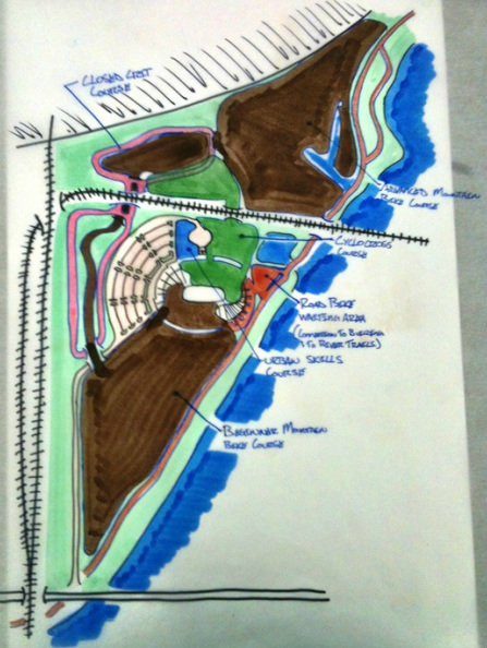
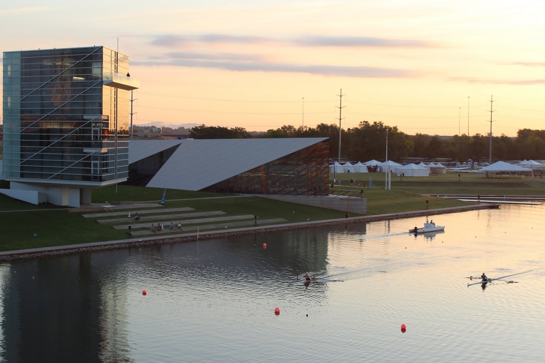
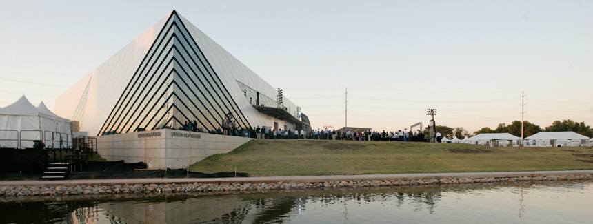
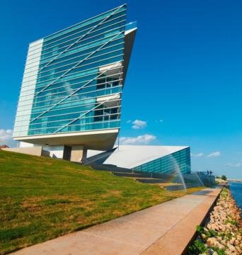
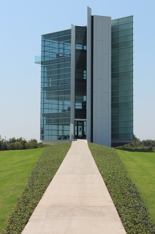
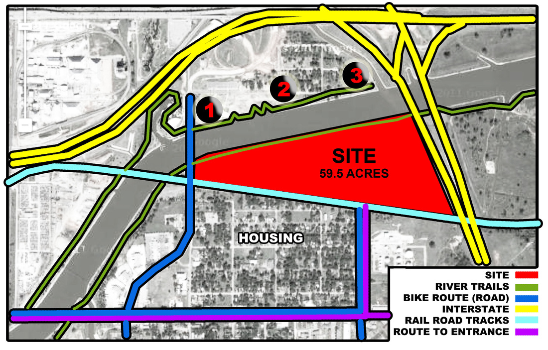
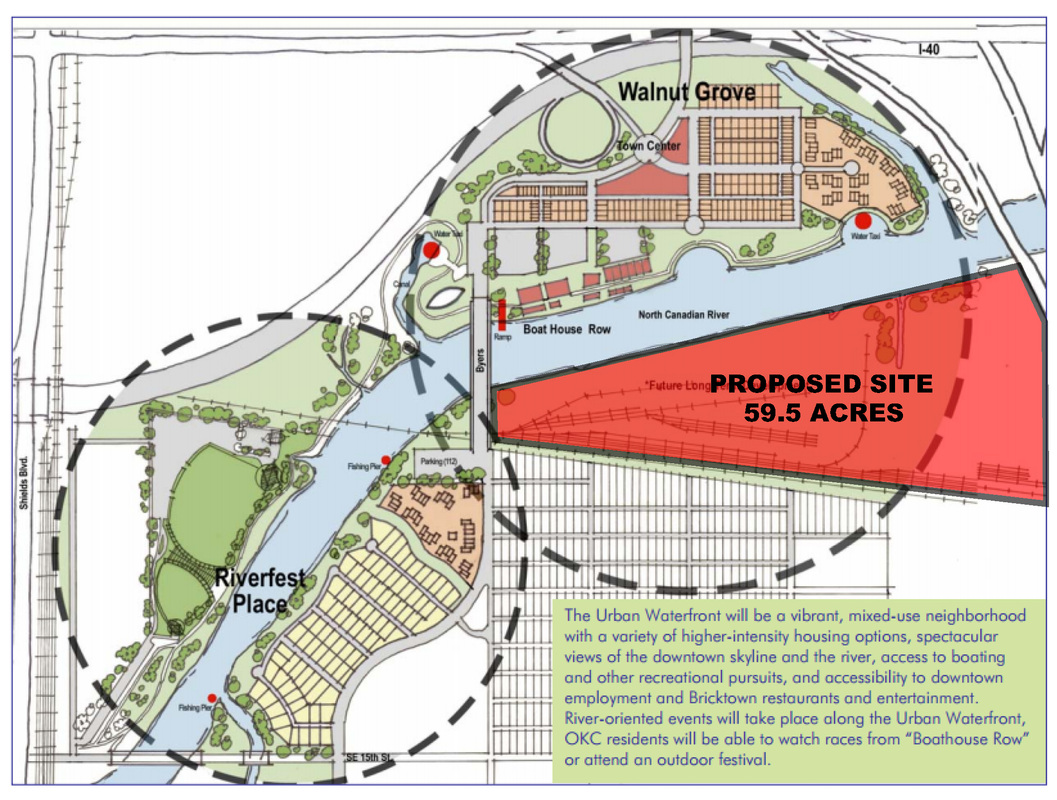
After talking to the Boathouse District Foundation Director a few weeks ago I got the impression he was very impressed with that I was designing for the area. His major concern was my location and the feasibility of being able to build there with the railroad currently owning the property. He said it was do able and he liked it but it was at least a 20 year project just get obtain the property and move the rail lines. He proposed to me a secondary location for my project (a site he is looking to develop in the near future). It is currently the "Pull-a-Part" Salvage yard North of the River between the main N/S railroad tracks and the Chesapeake Boathouse. He said this new location is the missing piece between the boathouse district and the new Downtown Park system the City is building as part of MAPS 3. He also said they are looking at trying to introduce more commercial spaces in that area as well to help draw people into the boathouse district. He listed a restaurant and office space being two of the more critical spaces. He then went on and stated that from what he has seen on my blog thus far that this would be something he would be interested in submitting to the city of Oklahoma City. That posed somewhat of a problem for me in that do I keep working on my original site (which is quite a bit larger) or do I switch sites with the thinking that my Thesis project might help spark what type of facility will end up there. I went out after our meeting and walked down the north side of the river trails and looked around the site he proposed to see what all it possessed and if it would still work for what I was wanting to accomplish. I printed out the Google maps image and started sketching sight lines and such and what all would be needed to change with my original building in order to accommodate the new site. Everything seemed to work out I did not have to change my building or rearrange spaces on the new site (which was my main time concern) so I am pushing forward with the new site. Placing my facilities in this new location will also connect and give the Chesapeake Boathouse something interesting to look at since it will go right up to the west end of the trail directly across their little waterway connecting to Bricktown.
0 Comments
# 3 Top Hail Prone Cities (Based on frequency and severity of hail)
# 2 Top Tornado States (Ave number of tornadoes per 10,000 square Miles, occurring from 1953-2004) # 1 Top Tornado Prone City (Ranked by tornadoes per 1,000 miles) Oklahoma encounters the highest number of significant and violent tornadoes per square mile. The first data point is going to play a major roll in me finding alternative ways of producing electricity on my site. Most of the time you use solar panels to produce a majority of your power needs but with severe hail being a major problem in the area I am afraid they will get broken or damaged on a yearly bases so instead of ignoring it I plan not to use them and provide a safer, less fragile power source. This data is why my facility will also be a FEMA rated structure and with it being net zero it would still have electricity and clean water in the case of a disaster. HERE: is my link to where I found this data... With my site being within the Boathouse District I want to continue the theme of buildings in the area so here are images of the 2 existing boat houses. Since the form of these two building relate directly to the art of rowing my building form will not match, however I plan to use simmular materials, finishes and lighting. Chesapeake BoathouseDevon Boathouse & Finishline TowerAll models will be round Now that the research is all done and the location has been selected it is time to start getting in depth with the site and surrounding area. This first model will be at 1"=400' scale so you can see my sites location in relation to the downtown OKC area. On this model I plan to show key features of the area using colored push pins I plan to show the following:
1. OKC River Trails network as well as other bicycling routes into and around the city, 2. Driving routes from major highways to the main entrances of the site and 3. The railroad tracks and how they detach my site from the community to the south. 4. Locations of the Spokies kiosks (rent-able bicycles in the downtown area) spokiesokc.com The model also shows travel distances from my site (red circles) to help show from what areas you could expect normal people to walk (1/4 to 1/2 mile) or bike (1 to 2 miles) to the facility. Avid cyclists as well as commuters are more likely to travel from greater distances to use the facilities. This map shows what all is planned for along the Oklahoma River system just south of downtown Oklahoma City. The area in red is my site and it is the only area in this entire area that is just listed as "future development". Once I saw this site was free I felt it was perfect for what I wanted to do. It was close to downtown and all the bicycling facilities that are currently being upgraded within the city and the site is large enough to accommodate the outdoor facilities I attend to design as well. This map shows the existing and proposed bicycling trails, pathways around me site showing that my site can be accessed by bicycle from just about anywhere within the Oklahoma City city limits. This map is closer and more relevant to my actual site. To the north is the Oklahoma River, to the south is a Railroad track, east is I-35 and west is Lincoln Blvd. There is housing planned directly south of my site with bike friendly streets heading in all four directions (North, South, East and West) from the site. The Oklahoma River trails system run between my site and the river and run uninterrupted east and west connecting to the existing network of trails and roadway shown above.
So why do I want to design a Velodrome in Oklahoma City? First and foremost, I am a cyclist, and as a cyclist in Oklahoma I do not own a track bike. If you were to ask a cyclist how many bikes they need, they will tell you one more than they currently own. Cyclists by nature are very competitive people who like the feeling of flying down descents at 40 mph and the feeling of the wind, knowing they can only go as fast as they are willing to push their bodies physically and mentally. That is why I want to design a velodrome in Oklahoma City. Why should Oklahoma City want to have a velodrome? That is the real question. Oklahoma has invested a lot of money into its trail networks both downtown (Project 180 and River trails network) as well as outside of the downtown area (Lake Hefner, Lake Overholser, Draper Lake etc…). The one thing they are trying to do now is connect them all together so that you can go just about anywhere in the Oklahoma City area by bike. The only problem with this is everything is so spread out it makes it difficult for normal people to ride on a daily basis. Say, for instance, you work in the downtown area, and after work you want to go ride your mountain bike. If you leave work at 5pm like almost everyone else you have to fight your way thru traffic to either Arcadia Lake, Bluff Creek (Lake Hefner), or Draper Lake, all of which would take you roughly 30 to 60 minutes to get there. Yes. I know I am referring to mountain biking and the original question pertains to a velodrome. The velodrome I am proposing is going to be the cycling hub to the city. Not only will there be a velodrome, but there will be outdoor tracks for mountain biking, cyclocross, and criterium racing. With it being just south of downtown you now have the option of riding your bike there from your place of work and avoid most of the traffic of everyone in their cars trying to leave the city. Once you are finished riding you ride back to your work, get in your car, and go home. Bringing in these four different forms of cycling also enables the site to be used all year round. A lot of your competitive cyclists do not just race one discipline. Most cyclists race all year to help get better and stronger for the next season. As the weather changes the style of riding also changes to maintain safe riding conditions. Why Oklahoma? First, Oklahoma is where I live. It is what I know. The cycling community here is growing with every passing year, and the number of cycling teams in the area is growing as well. I knew there was at least one velodrome within driving distance for a weekend race (Superdrome- Frisco, TX), but I wasn’t sure how many there actually were in the entire US. I found a website that lists all the velodromes in the United States and whether they are indoor or outdoor facilities. I then downloaded a map off the internet and started placing circles at the locations of each velodrome (Outdoor-red, Indoor-blue stripes, OKC-green) What demand is there in Oklahoma for a cycling facility? According to the USA Cycling website there are 33 registered cycling teams in Oklahoma this year (2012) and of those teams 18 are within a one-hour drive to downtown Oklahoma City. The furthest teams are from Owasso, OK, just northeast of Tulsa so they are just over a two-hour drive away. All of these teams participate is road racing type events because those are the easiest to train for around here. There are a number of mountain biking trails in the area that also allow for racing, but cyclocross racing is somewhat limited. The easiest way to explain cyclocross is it is racing over various terrains in the bitter cold. For a good cyclocross course you need hills, grass, asphalt, sand and/or gravel. There also needs to be barriers tall enough that you have to get off your bike and carry it over. Finding these kinds of elements together in Oklahoma is difficult and where they do happen (OKC parks areas), there is limited or no access to those facilities. Having an area designated for cyclocross racing where these elements are present but you can still choose what paths to take can be huge for the area. This hub would not just be utilized by Oklahomans, but cyclists from surrounding states would come down to races thus helping the economy because these people would, in turn, utilize the area’s resources for food and lodging. The other benefit of having it in Oklahoma City is the fact it is close to a number of collages that could use the facility as well. The 2 main ones being The University of Oklahoma and Oklahoma State University, which already have established road cycling teams. Other possibilities being Oklahoma Baptist and Oklahoma Christian University that have sports programs but do not currently have cycling teams. The boathouse district is also the home of the local collegiate rowing teams as well so this would help keep the collegiate scene all in one place. Downtown Oklahoma City is in the beginning stages of a total transformation. With the opening of the new I-40 Crosstown and the total redevelopment along the Oklahoma River, this is the most ideal time to design this type of facility into the master plan of the area. I want to use the site that no one else knows what to do with. I want to design this facility in such a way to help buffer the noise from the railroad tracks so it does not interfere with what is going on down on the river and boathouse areas. I think my design will help unify this area as the “sports district” and not just the boathouse district.
There are two other things I am looking at proposing as a part of my facility. First, I want to include commercial and restaurant spaces within my velodrome facility that are located around the perimeter in that they can be open and operated separate from the facility so you can still eat and shop when the facility is not open. With higher density mixed use neighborhoods both north and west of my site it makes sense to incorporate these facilities here so that people in this community do not have to travel north into the city in order to shop or eat. It allows for a better quality building and overall site. It also will get people on my site that might not be associated with cycling and allow them to see the facility without having to come here with that purpose in mind. Second, I want to incorporate a pedestrian bridge at the east end linking the boathouses to my site. The closest existing crossing access is approximately a mile to the west at Wiley Post Park. This access will allow spectators of the rowing events access to the south shores to watch rowing events from both sides of the river. It will allow people working/using the boathouse facilities access to my commercial/retail stores. It will also allow my site and the boathouse facilities to share parking. With the location of my site bordering the railroad tracks to the south, my main entrance has the possibility to be blocked several times a day. I have yet analyzed how the railroad could potentially affect my site, but it is on my list of things to do. I am still going to have a main entrance and parking for various activities, but being able to share parking like this can help create more green spaces and allows people to park at one facility but use them all. I am starting on my site analysis today and thought it would be good to visit the site and walk around a bit since the weather is so nice. Here are some photos I took from various points north of the river looking at my site. I was also able to go to the top of the Devon Finish Line Tower and snap a few photos from there as well. In all photos my site is highlighted red. While at the boathouse today I got to talking with the guy at the front desk about various things happening in the area and a part of the scope of the future of the boathouse district. I talked about wanting to design a bridge to allow foot traffic back and forth thus allowing people to have access to both sides of the river for rowing events also. These are the main public views I am going to design as the front of by building. The other side is where the main driving entrance is and that will also be addressed but the rest of that side is along the rail road tracks so I am seeing various trees/burms hiding that and blocking the noise of the trains.
|